Software
5 Best Drone Software Platforms (2025)
Managing drone operations – from mission planning and data capture to compliance and analysis – is now a critical need for freelance pilots and enterprise fleets alike. Below we present the top five drone software platforms in 2025, ranked in a journalistic review style. Each platform includes an overview of features and ideal use cases, a candid list of pros and cons, real-world project examples, and an explanation of why it earned its position on this list. All claims are backed by factual references to ensure accuracy and realism in our assessments.
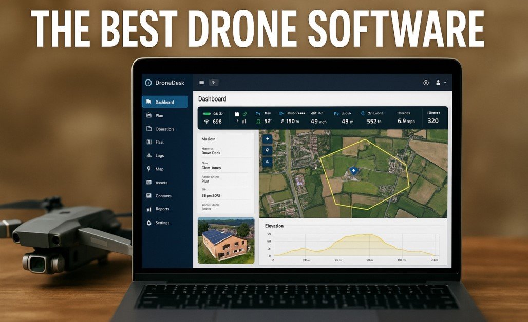
1. Dronedesk – All-in-One Operations Hub for Drone Businesses
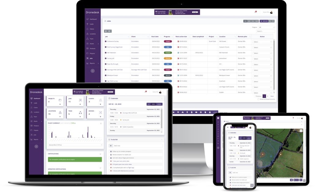
Dronedesk stands out as a comprehensive drone operations management platform purpose-built to streamline every facet of professional UAV work. It consolidates flight planning, client and asset management, airspace intelligence, team coordination, and compliance reporting in one intuitive dashboard. By eliminating the need for multiple disjointed tools (or clunky spreadsheets), Dronedesk dramatically reduces administrative overhead – users report it cuts job planning time by at least 50%. The platform features direct integration with DJI drone data for automatic flight logging and maintenance tracking, though it supports other brands with additional setup. Scalable pricing (including a free trial and money-back guarantee) makes it accessible from solo freelancers to large enterprises. Dronedesk has earned a 5.0 user rating (Trustpilot) from over 350 pilots and is trusted by 2,400+ operators – a testament to its effectiveness in real-world use.
Pros and Cons
- End-to-End Management: Centralizes client info, project planning, flight logs, equipment maintenance, and team communications in one place. This holistic approach streamlines workflows and ensures nothing falls through the cracks.
- Advanced Flight Planning & Safety: Offers rich airspace and proximity intelligence with live maps and alerts, plus built-in risk assessment and checklists for compliant missions. DJI synchronization enables effortless log downloads and geo-awareness.
- Robust Reporting & Compliance: Auto-generates documentation like risk assessments, maintenance logs, and financial reports, simplifying regulatory compliance audits. Operators can quickly demonstrate adherence to civil aviation rules.
- Highly Rated Support and Usability: Pilots praise its user-friendly interface and responsive developer support. Extensive tutorials and customer service help new users get up to speed despite the platform’s breadth.
- Scalable for Teams: Multi-user features like task assignments and cloud sharing allow small teams and large fleets alike to coordinate efficiently. Pay-as-you-grow pricing tiers accommodate startups and scale-ups without steep upfront costs.
- Feature Overload for Casual Users: The very richness that benefits power users may feel overwhelming to occasional flyers. Pilots with minimal operations might not utilize all modules, making the interface seem complex.
- DJI-Centric Integrations: While it works with any drone, many automated features (like direct log import) are optimized for DJI products. Users of other brands may need manual data imports or third-party bridges, adding setup time.
- Initial Learning Curve: Implementing such a comprehensive tool requires some onboarding effort. New teams may need to invest time in training and configuring Dronedesk to their workflow, though guides and support are available.
Visit DroneDesk
2. DroneDeploy – Leader in Aerial Mapping & Data Analytic Drone Software Platforms
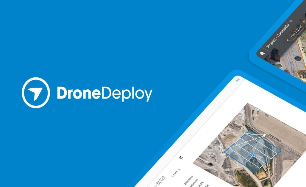
DroneDeploy is a powerhouse in drone software, known for its easy-to-use cloud platform for mapping, modeling, and analysis. It began as a tool for automated flight and photogrammetry, and over the years has evolved into a full “reality capture” suite spanning aerial and ground data capture. Companies across construction, agriculture, mining, and energy rely on DroneDeploy to plan drone missions, process imagery into maps/3D models, and extract insights like volumes, measurements, and change over time. The platform offers one-click automated flights with supported drones, real-time processing (viewing maps even as the drone is in the air), and collaboration features that let teams access the data from anywhere.
DroneDeploy also integrates with many enterprise systems (from Procore in construction to John Deere in agriculture), fitting into existing workflows. Its emphasis on a streamlined end-to-end workflow – from flight to cloud to analysis – has made it a top choice for scaling drone operations across multiple sites. Whether you’re a solo pilot mapping a field or an enterprise managing dozens of drones, DroneDeploy provides a centralized dashboard to monitor flights, hardware status, and compliance (including basic airspace info).
Pros and Cons
- Intuitive Interface: DroneDeploy is widely praised for a clean, user-friendly interface and app. New users can get a basic mission up and running quickly, and seasoned pilots appreciate the efficient layout of tools. This lowers the training burden for organizations.
- Automated Mapping & Modeling: The platform excels at generating high-quality orthomosaics, 3D models, and analyses with minimal manual effort. It automates flight paths for consistent coverage and even handles real-time processing of data for instant previews. Advanced algorithms convert imagery to actionable data (like stockpile volumes or plant health indices) in a few clicks.
- Rich Analytics and Reporting: Beyond maps, DroneDeploy includes built-in analytics – for example, construction teams can track earthwork progress and detect site changes, and farmers can pinpoint crop stress areas. The software’s reports and annotations allow users to turn raw imagery into decisions (e.g., identifying where a project is behind schedule or which fields need fertilizer).
- Mobile and Cloud Collaboration: Its mobile app lets field teams plan flights and capture data on-site, while cloud sync makes results immediately available to remote stakeholders. This is ideal for large projects where engineers, inspectors, or clients in different locations need prompt access to drone findings.
- Integration & Extensibility: DroneDeploy’s App Market and APIs enable integration with other business software. It can plug into project management tools, GIS databases, or machine learning systems. For enterprises, this means drone data flows seamlessly into their broader information systems.
- Cost for Advanced Features: DroneDeploy operates on a tiered subscription model, and the price climbs steeply for full functionality. Small businesses may find the higher-tier plans costly, especially to unlock features like advanced AI analysis, unlimited cloud storage, or fleet management tools. Budget-conscious users might only afford lower tiers with limited capabilities.
- Learning Curve on Depth: While basic use is straightforward, mastering DroneDeploy’s full feature set (e.g., setting ground control points for survey-grade accuracy, or utilizing its Python SDK) requires training. Organizations often invest time to train pilots or hire specialists to exploit its more sophisticated features.
- Primarily Mapping-Oriented: DroneDeploy’s strength is in mapping/visuals; it is less focused on some operational aspects like maintenance tracking or pilot certification management. It lacks the granular fleet health analytics of a tool like AirData or the deep compliance features of Dronedesk. Users needing those might need to use DroneDeploy in combination with other software.
Visit Dronedeploy
3. Pix4D – Precision Photogrammetry and 3D Mapping Suite
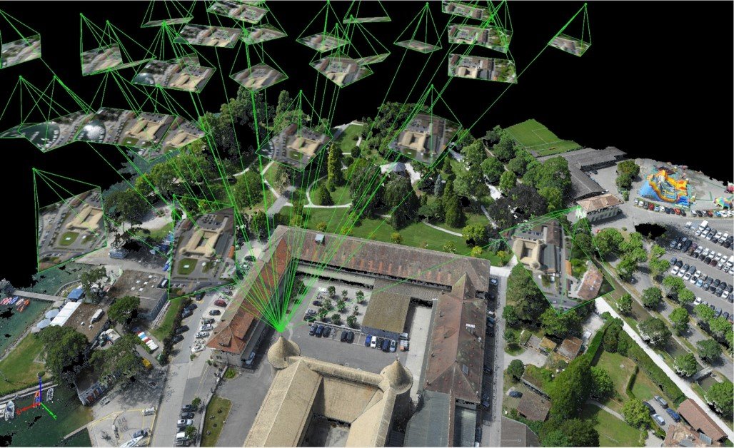
Pix4D is a renowned drone software platform specializing in high-precision photogrammetry and geospatial data processing. It offers a suite of products (Pix4Dmapper for general mapping, Pix4Dfields for agriculture, Pix4Dreact for emergency mapping, and more) that cater to professionals who demand accuracy and control over their data. Unlike purely cloud-based solutions, Pix4D provides powerful desktop applications which allow offline processing of images into point clouds, orthomosaics, digital surface models, and textured 3D models.
This makes it popular with surveyors, GIS specialists, and engineering firms who often need survey-grade results and may operate in remote areas. Pix4D’s flight planning apps incorporate advanced features like terrain following (the drone adjusts altitude to the ground relief) to ensure consistent image resolution, and support for multi-drone missions and oblique imagery for detailed 3D reconstruction. Critically, Pix4D software integrates ground control points (GCPs) and RTK GPS data seamlessly, enabling centimeter-level accuracy in outputs when required. The platform is known for its rich toolkit – users can tweak many processing parameters, generate customized outputs, and perform analyses like volume calculations or contour line generation within the software. While Pix4D can be complex and is on the premium end of pricing, it’s regarded as an industry standard for drone mapping when precision and versatility are paramount.
Pros and Cons
- Professional-Grade Accuracy: Pix4D is built with surveyors in mind. It yields highly accurate maps and models when proper techniques (like GCPs or RTK drones) are used. For projects where accuracy can’t be compromised (e.g. cadastral surveys, infrastructure design), Pix4D’s algorithms and support for precision inputs shine.
- Comprehensive Outputs: The software can produce an array of geospatial outputs – dense point clouds, orthomosaic maps, digital elevation models, 3D textured meshes, thermal maps, multispectral indices, etc. This flexibility means one dataset can serve multiple purposes. For instance, from one drone flight a user could get a map for an inspection report and also a 3D model for a client visualization.
- Specialized Modules: Pix4D offers tailored solutions: Pix4Dfields for farming (with crop health analysis tools), Pix4Dmapper for general mapping, Pix4Dsurvey to extract CAD-ready vectors from point clouds, Pix4Dreact for fast mapping in emergencies, etc. These targeted products come with features and UI optimized for those domains (e.g., agriculture users get plant health tools, public safety users get speedy 2D mapping for disaster scenes).
- Offline and On-Premise Capabilities: Users retain full control of data by processing locally. This is a big plus for projects with sensitive data (defense, mining, etc.) or in bandwidth-limited regions. Pix4D’s software can leverage high-end PCs or servers to crunch imagery without needing an internet connection or cloud subscription.
- Integration & Export: Pix4D results can be easily exported to other systems (industry-standard formats like LAS, OBJ, GeoTIFF, etc. are supported). It integrates well with CAD and GIS workflows – for example, surveyors can bring Pix4D models into AutoCAD or ESRI software smoothly. This inter-operability is crucial for professional use where drone data must fit into larger engineering pipelines.
- Steep Learning Curve: Mastering Pix4D requires some expertise in photogrammetry. Users must learn about camera settings, flight plans, and processing options to get optimal results. The software interfaces are dense with technical settings compared to more automated tools. Training or prior GIS knowledge is often needed to fully leverage Pix4D’s capabilities.
- High Cost for Licenses: Pix4D’s professional focus comes with a premium price. Licenses can be expensive, especially if one needs multiple modules (e.g. mapper + survey + fields). While they have subscription and perpetual license options, the investment is significant for small operators. Some features (like cloud processing or frequent updates) may require ongoing fees.
- Hardware Demands: Processing high-resolution imagery into detailed 3D models is computationally intensive. To use Pix4D efficiently, a powerful computer with a dedicated GPU, ample RAM, and disk space is recommended. Without strong hardware, large projects can be very slow to process or may even fail. This can be a barrier for users without high-end workstations.
- Limited Real-Time Collaboration: Unlike cloud platforms, Pix4D’s workflow is not inherently collaborative in real-time. Team members can’t simultaneously work on a project live; they typically have to share large files after processing. (Pix4Dcloud offers some collaboration via the web, but it’s an add-on service and not as integrated as DroneDeploy’s real-time sharing, for example.)
Visit Pix4D
4. AirData UAV – Fleet Logging, Maintenance & Safety Analytics
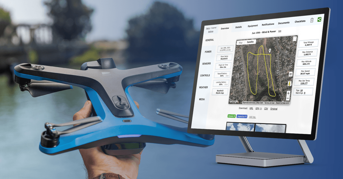
AirData UAV is a cloud-based drone fleet management platform that excels in automated flight logging, equipment tracking, and safety analytics. Think of it as a digital logbook and maintenance inspector for all your drone operations. Whenever a drone flight is completed, AirData (which integrates with DJI, Autel, Parrot, and many other systems) will automatically ingest the flight data – recording everything from GPS tracks and battery levels to weather and pilot info. It then presents fleet managers with dashboards on aircraft status, pilot currency, component wear-and-tear, and more. Preventative maintenance is a core strength: AirData sends alerts when a drone or battery is due for service based on hours flown or charge cycles. It also analyzes flight logs for anomalies (like battery voltage drops or IMU errors) to flag potential safety issues before they lead to incidents.
This focus on reliability and compliance makes AirData especially valuable for large drone programs, where keeping dozens of drones and pilots safe and airworthy is a challenge. The platform supports teams of all sizes – from hobbyists (even a single user on a free/low-cost plan) up to enterprises with thousands of flights per day. In fact, AirData boasts that it’s helping “hundreds of thousands of drone operators worldwide” and logging thousands of new flights every day on its system. It also offers tools like live flight streaming and flight sharing for collaboration, and recently, features for public transparency of drone operations (important for law enforcement use). While AirData is not a mapping tool, it is often used alongside mapping software to ensure all operational aspects of drone use are monitored and recorded.
Pros and Cons
- Comprehensive Flight Logging: Every detail of each flight (telemetry, sensor data, locations, battery health, etc.) is captured and stored automatically. This eliminates manual logbook entries. Pilots and managers can review flights after the fact, replay them, and export data for reports.
- Fleet Health & Maintenance Alerts: AirData tracks the usage of each drone and battery in a fleet and issues alerts for scheduled maintenance or when performance metrics drop below safe thresholds. For example, you might get a notification that Drone #5’s propellers have 50 flights and should be inspected, or that Battery #12 has a cell imbalance. This predictive maintenance prevents accidents and extends equipment life.
- Pilot Management & Compliance: The system can store pilot certifications, track flight hours per pilot, and even notify when a certification is nearing expiry. It helps organizations ensure each pilot is current with training and operating within regulatory limits (like UAV weight classes or daylight-only flying, etc.). For agencies, it generates the documentation needed to prove compliance to regulators.
- Cross-Platform Versatility: AirData isn’t tied to one drone manufacturer. It supports DJI, Skydio, Autel, Yuneec, Parrot, custom ArduPilot rigs, and more via log import or apps. This makes it a one-stop hub for mixed fleets. Whether a company has 5 different drone models or switches brands, they can keep using AirData as the consistent fleet monitor.
- Data Insights and Safety Features: The platform’s analytics can reveal patterns – e.g., if one battery shows consistently shorter flights (indicating it’s aging) or if a particular drone model in the fleet has frequent compass errors. AirData also provides flight debriefs with maps and graphs, which is useful for incident investigations or improving pilot techniques. Additionally, features like live streaming and real-time fleet monitoring can enhance operational awareness during missions (e.g., a command center watching multiple drone feeds via AirData).
- Limited Mapping/Survey Tools: AirData is not designed for data processing or mapping outputs. It stores photos and videos but doesn’t create maps or 3D models. Users focused on mapping will need separate software and possibly integrate AirData via its API for a combined workflow. Essentially, AirData is about the flight and the drone’s health, not about the imagery data product.
- Advanced Features in Paid Tiers: While AirData offers a basic free version (good for hobbyists) and affordable personal plans, many of the most powerful features (custom alerts, deep analytics, API access, large team support) are in higher-tier or enterprise plans. Small businesses might find they quickly outgrow the basic tier and need to pay more for features like unlimited data retention or multiple user accounts. It requires careful consideration of needs to choose the right plan.
- User Interface Complexity: Given the wealth of telemetry data AirData presents, the dashboard can be overwhelming at first. New users (especially non-technical managers) might be daunted by graphs of battery voltages, IMU angles, etc. There is a learning curve to interpreting all the indicators and setting up the system optimally (e.g., configuring which alerts you want to receive). However, AirData provides tutorials and a support forum to help users get comfortable.
- Reliance on Cloud/Uplink: To get the most value, drones or their apps need to upload flight logs to AirData regularly (either in real time or post-flight). In the field with no internet, logs will sync later. This isn’t usually a problem, but real-time fleet tracking features obviously require connectivity. Organizations with strict data secrecy might also be hesitant to upload flight details to a cloud service (though AirData does have enterprise options for private hosting).
Visit AirData UAV
5. Aloft (Kittyhawk) – Airspace Compliance and Enterprise UTM Drone Software Platforms

Overview: Aloft, formerly known as Kittyhawk, is a leading software platform focused on airspace management, compliance, and streamlined flight operations. It serves both as a fleet management tool and as a Unmanned Traffic Management (UTM) service provider, bridging the gap between drone operators and airspace authorities.
Aloft’s claim to fame is its deep integration with the FAA’s systems in the United States: it powers FAA applications like B4UFLY (the official hobbyist airspace awareness app)and handles the majority of digital airspace authorizations (LAANC). In fact, as of 2022, Aloft was facilitating over 70% of all LAANC authorizations in the U.S. – meaning most commercial drone pilots requesting to fly in controlled airspace (near airports, etc.) use Aloft’s system to get automatic clearance. For enterprise and government users, Aloft’s platform (formerly called Kittyhawk Air Control) provides real-time airspace intelligence, flight planning with built-in NOTAM/TFR data, digital checklists and risk assessments, live flight tracking, and post-flight logging, all in one solution.
Teams can assign roles, set geofencing rules, and enforce company SOPs through the software. Aloft is accessible via web and a very popular mobile app, enabling field operators to quickly check airspace and get LAANC approvals on their phone within seconds. The platform emphasizes regulatory compliance workflows – documenting every flight approval and pilot credential – which is why it’s used heavily in industries like insurance, utilities, and public safety that have to answer to strict oversight. Overall, Aloft acts as a smart co-pilot that makes it easy to “fly safe and legal,” while also providing enterprise features for fleet oversight and data security.
Pros and Cons
- Industry-Leading Airspace Intelligence: Aloft provides up-to-the-minute airspace data (controlled zones, temporary flight restrictions, local advisories, etc.) and streamlines the process of obtaining FAA approvals to fly in restricted airspace. Its LAANC integration is second to none – authorizations that used to take days now take about ~30 seconds via Aloft’s app, which is critical for operators needing to adapt on the fly.
- Streamlined Compliance Workflow: The platform automates much of the paperwork: digital pre-flight checklists, auto-generated flight logs, pilot profiles with certifications, and even compliance reports. This significantly reduces the admin burden on teams to prove they followed all rules. For enterprises, Aloft acts like a compliance officer that is always on.
- Excellent Mobile App Experience: Aloft’s mobile app (born out of Kittyhawk) is highly regarded for its usability in the field. Pilots can plan a mission, run a checklist, check all airspace constraints, and get LAANC clearance all from their phone or tablet on site. The ease of use encourages pilots to actually follow safety steps rather than skip them.
- Fleet and Team Management: For organizations, Aloft offers robust multi-user support. Administrators can assign roles/permissions, so for example a junior pilot can be restricted from flying in certain airspace unless a supervisor approves in-app. The platform also tracks operational metrics (flight hours per drone/pilot, etc.) and can integrate with other systems via API. This allows a large company to manage dozens of pilots and drones with central oversight on a secure system.
- UTM and Future-Ready Features: Aloft is at the forefront of UTM (unmanned traffic management). It’s involved in remote ID technology and even drone delivery airspace systems. For enterprise users, this means the platform is evolving to handle things like real-time drone tracking on the network, de-confliction between multiple drones, and compliance with future regulations. By using Aloft, companies are essentially future-proofing their operations for the coming era of increased airspace integration.
- Data Analysis Not a Focus: Aloft’s strength is in flight ops and compliance, but it has limited capabilities for data processing or analysis (e.g. it won’t stitch maps or do AI inspection on images). Users often use Aloft in tandem with data-centric tools (like DroneDeploy or Pix4D) – Aloft takes care of getting the flight authorized and logged, then another tool handles the images collected.
- Paywall for Advanced Enterprise Features: While Aloft offers a free tier (useful for hobbyists or small outfits mainly for airspace checks and basic logging), advanced features like enterprise fleet management, deeper integration, and custom risk assessment forms come with paid plans. Large organizations likely need those premium tiers, which require contacting Aloft for pricing. This can be a barrier for mid-size businesses that want more than the free features but aren’t large enough for a custom enterprise deal.
- U.S.-Centric Airspace Services: Aloft is heavily U.S.-focused due to its FAA partnership. Its airspace data and LAANC are U.S. only. International users can still use it for logging and internal management, but may find less built-in data for their country’s airspace (unless those countries integrate with Aloft or Kittyhawk’s data). Thus, its full value is best realized by U.S. operators or global companies operating under FAA rules. Others might have to manually import local no-fly zones or use country-specific solutions for airspace.
- Sync/Connectivity Issues (Occasional): Some users have reported that syncing data between mobile and web or across team accounts can sometimes glitch, requiring a restart or re-sign-in. These instances appear infrequent, but for a mission-critical ops tool any tech hiccup can be frustrating. Aloft has been improving this, but it’s a consideration.
Visit Aloft (Kittyhawk)
5 Best Drone Software Platforms Conclusion
The drone software ecosystem in 2025 is rich and varied, but these five platforms have risen to the top by addressing the key needs of professional drone programs. Dronedesk provides the all-in-one command center that many businesses rely on to save time and stay compliant. DroneDeploy and Pix4D deliver the actionable data and mapping insights that turn drone flights into business value, each excelling in their way – user-friendly scalability for DroneDeploy, and hardcore accuracy for Pix4D. AirData and Aloft might operate behind the scenes, but they are the backbone of safety and legality, ensuring that drone operations remain reliable and rule-abiding at all times.
Together, these platforms form a comprehensive toolkit for any serious drone team, from a lone freelancer building their client base to a multinational enterprise scaling an aerial fleet. The rankings here reflect a careful consideration of features, real-world performance, user feedback, and the unique strengths each solution brings to the table. As the drone industry continues to mature, leveraging the right software will be just as important as the hardware – and the above top 5 are leading the way in empowering drone pilots to fly smarter, safer, and more effectively than ever before.