Definition
GNSS stands for Global Navigation Satellite System. It refers to a constellation of satellites that provide global positioning, navigation, and timing (PNT) services. GNSS includes systems such as GPS (United States), GLONASS (Russia), Galileo (European Union), and BeiDou (China).
Relevance to the Industry
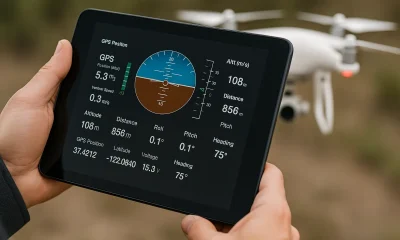
GNSS is fundamental to modern drone technology, providing the essential data needed for precise and reliable navigation. The integration of GNSS with drones enhances their capabilities, allowing for autonomous flight, real-time tracking, and high-precision operations. This technology is critical for achieving operational efficiency and safety in diverse drone applications.
How Does Global Navigation Satellite System (GNSS) Work?
Global Navigation Satellite Systems (GNSS) are satellite-based systems that provide geospatial positioning with global coverage. GNSS technology allows users to determine their location (latitude, longitude, and altitude) and time with high precision anywhere on Earth. Here’s a detailed explanation of how GNSS works:
1. System Components
- Satellites: A constellation of satellites orbiting the Earth, each transmitting signals that include its position and the exact time the signal was sent.
- Ground Control Stations: Facilities on the ground that monitor and manage the satellite constellation, ensuring the accuracy and health of the satellites.
- GNSS Receivers: Devices that receive signals from multiple GNSS satellites to calculate the user’s position and time.
2. Key GNSS Systems
- GPS (Global Positioning System): Operated by the United States, GPS is the most widely used GNSS.
- GLONASS (Global Navigation Satellite System): Operated by Russia, GLONASS provides global coverage similar to GPS.
- Galileo: Operated by the European Union, Galileo aims to provide highly accurate positioning services.
- BeiDou: Operated by China, BeiDou offers global navigation services with a focus on the Asia-Pacific region.
3. Signal Transmission
- Satellite Signals: Each GNSS satellite continuously transmits a signal that includes:
- Ephemeris Data: The satellite’s precise position in orbit.
- Almanac Data: Information about the status and orbits of all satellites in the constellation.
- Timing Information: The exact time the signal was transmitted, based on highly accurate atomic clocks onboard the satellites.
4. Signal Reception and Processing
- Receiving Signals: A GNSS receiver on the ground or in a vehicle receives signals from multiple satellites.
- Time of Flight Calculation: The receiver calculates the time it took for each signal to travel from the satellite to the receiver. Since the speed of light is known, this time is used to calculate the distance to each satellite.
- Triangulation: By knowing the distance to at least four satellites, the receiver can use trilateration to determine its precise position (latitude, longitude, and altitude).
5. Position Calculation
- Distance Measurement: The receiver measures the distance to each satellite based on the time delay of the received signals.
- Intersection of Spheres: Each distance measurement defines a sphere with the satellite at its center. The intersection of these spheres determines the receiver’s position.
- Error Correction: The receiver uses various techniques to correct for errors caused by atmospheric conditions, satellite clock discrepancies, and other factors. Differential GNSS (DGNSS) and Real-Time Kinematic (RTK) are examples of methods used to enhance accuracy.
6. Applications and Use Cases
- Navigation: GNSS is used in aviation, maritime, and terrestrial navigation, providing accurate positioning data for safe and efficient travel.
- Mapping and Surveying: Surveyors and cartographers use GNSS for precise mapping and land surveying, enabling the creation of detailed maps and geographic information systems (GIS).
- Timing and Synchronization: GNSS provides precise timing information essential for telecommunications, financial transactions, and power grid management.
- Agriculture: Farmers use GNSS for precision farming, optimizing planting, fertilization, and harvesting operations.
- Geocaching and Outdoor Activities: GNSS is popular in recreational activities such as geocaching, hiking, and boating, providing reliable location data in remote areas.
7. Advantages and Challenges
- Advantages:
- Global Coverage: GNSS provides worldwide coverage, allowing accurate positioning anywhere on Earth.
- High Precision: Advanced techniques like DGNSS and RTK offer centimeter-level accuracy, essential for high-precision applications.
- Versatility: GNSS is used in various industries and applications, from navigation to scientific research.
- Challenges:
- Signal Blockage: GNSS signals can be blocked by obstacles such as buildings, mountains, and dense foliage, reducing accuracy in urban and forested areas.
- Interference and Jamming: GNSS signals are vulnerable to interference and intentional jamming, which can disrupt positioning services.
- Multipath Effects: Signals reflected off surfaces can cause errors in distance measurements, affecting accuracy.
8. Technological Advances
- Multi-Constellation Receivers: Modern GNSS receivers can use signals from multiple GNSS systems (GPS, GLONASS, Galileo, BeiDou) simultaneously, improving accuracy and reliability.
- Augmentation Systems: Systems like the Wide Area Augmentation System (WAAS) and the European Geostationary Navigation Overlay Service (EGNOS) provide additional correction signals to enhance GNSS accuracy.
- Integration with Other Sensors: Combining GNSS with other sensors such as inertial measurement units (IMUs) and barometric altimeters improves positioning accuracy and reliability, especially in challenging environments.
Understanding how Global Navigation Satellite Systems (GNSS) work highlights their crucial role in providing accurate and reliable positioning and timing information worldwide. By leveraging a constellation of satellites, ground control stations, and advanced receiver technology, GNSS enables a wide range of applications in navigation, mapping, agriculture, and beyond.
Example in Use
“The drone utilized GNSS to maintain accurate positioning during its mapping mission, ensuring precise geospatial data collection.”
Frequently Asked Questions about GNSS (Global Navigation Satellite System)
1. What are the different GNSS systems, and how do they work together?
Answer: The main GNSS systems include:
- GPS (Global Positioning System): Operated by the United States, it provides global coverage and is widely used for navigation and positioning.
- GLONASS (Global Navigation Satellite System): Operated by Russia, it offers global coverage and can be used in conjunction with GPS for improved accuracy.
- Galileo: Operated by the European Union, it provides high-precision positioning and timing services.
- BeiDou: Operated by China, it offers global navigation and positioning services. These systems work together through multi-GNSS receivers that can process signals from multiple constellations, enhancing positioning accuracy and reliability.
2. Why is GNSS important for drone operations?
Answer: GNSS is important for drone operations because it:
- Provides Accurate Positioning: Ensures precise location data for navigation, flight planning, and georeferencing.
- Enables Autonomous Flight: Allows drones to perform complex tasks and follow pre-programmed routes without human intervention.
- Enhances Safety: Provides reliable data for real-time tracking and collision avoidance.
- Improves Efficiency: Supports efficient route planning and operational execution, reducing time and resource consumption.
3. What are the challenges associated with using GNSS in drone operations?
Answer: Challenges associated with using GNSS in drone operations include:
- Signal Interference: GNSS signals can be affected by obstacles, such as buildings, trees, and terrain, leading to signal loss or degradation.
- Jamming and Spoofing: GNSS signals can be intentionally disrupted or deceived, posing security risks.
- Multi-Path Effects: Signals can reflect off surfaces, causing errors in positioning data.
- Dependency on Satellite Visibility: Reliable GNSS performance requires a clear line of sight to multiple satellites, which can be challenging in certain environments.
For examples of these acronyms visit our Industries page.