Software
5 Best Drone Flight Planning Software (2026)

When every meter counts and compliance is non-negotiable, reliable flight planning software becomes essential for drone operators. Whether you’re a solo pilot surveying farmland or managing a fleet inspecting infrastructure, the right software can boost your precision, enhance safety, and save time in the field. Below, we explore the best drone flight planning software tools designed to help pilots fly smarter, not harder.
1. Dronedesk – End-to-End Planning with Compliance Built In Flight Planning
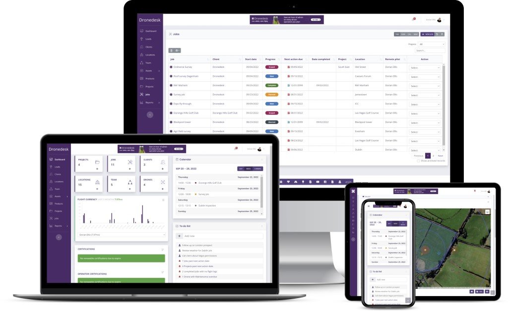
Dronedesk stands out as an all-in-one platform that simplifies flight planning, operational compliance, and client management. Tailored for commercial drone operators, Dronedesk lets you plan missions with precision while ensuring you meet airspace restrictions, log your flights, and keep insurance and documents up to date.
Key Features:
Easy airspace and NOTAM checks
Detailed mission planning and route optimization
Built-in risk assessments and pre-flight checklists
Pilot and equipment tracking for compliance reporting
Integrated CRM and invoicing for businesses
Pros and Cons
- Comprehensive mission planning with built-in risk assessments
- Automated compliance tools for airspace, insurance, and pilot records
- CRM, invoicing, and document storage in one interface
- Designed specifically for commercial drone operators
- Excellent support for multi-operator workflows
- UK-based software, some features may need adaptation for international users
- Not focused on photogrammetry or 3D modeling
- Limited in-flight control features compared to DJI-native apps
Why it’s flight planning is great for safety: Dronedesk incorporates built-in safeguards that flag non-compliant operations before takeoff, ensuring your missions are safe, legal, and well-documented.
Visit Dronedesk
2. DroneDeploy – Intuitive Mapping and Automation for Flight Planning
DroneDeploy is among the most popular tools for automated flight planning, especially in agriculture, construction, and inspection. Its cloud-based platform lets you plan routes, launch automated flights, and process high-resolution maps and 3D models in a matter of clicks.
Key Features:
Easy drag-and-drop waypoint creation
Real-time map previews
Automated mapping, inspection, and terrain-aware flights
Compatibility with major drone brands
Powerful post-processing and analysis tools
Pros and Cons
- Excellent for automated mapping and 3D modeling
- Cloud-based interface for real-time collaboration
- Supports high-precision agricultural and construction workflows
- Strong third-party integrations (e.g., John Deere, Procore)
- Mobile and desktop mission planning
- Subscription costs can be high for premium features
- Limited offline functionality
- Focused more on data products than custom flight dynamics
Why it’s great for precision Flight Planning: DroneDeploy’s smart planning tools ensure high overlap and accuracy, reducing reshoots and post-processing errors.
Visit Dronedeploy
3. Litchi – Versatile Mission Planning for Hobbyists and Pros

If you want more control over camera angles, waypoints, and gimbal behavior, Litchi is a top pick. Popular with DJI pilots, it allows for detailed flight route programming and camera control via desktop and mobile.
Key Features:
VR mode and FPV support
Waypoint missions with customizable speed, altitude, and POI focus
Offline planning with Google Earth integration
Cross-device mission syncing
Pros and Cons
- Advanced waypoint mission planning for DJI drones
- Control over gimbal angles, camera settings, and flight behavior
- Offline mission planning with Google Earth support
- Great for cinematic and creative work
- Affordable one-time app purchase
- DJI-specific — doesn’t support non-DJI drones
- No cloud backup or team collaboration features
- Lacks compliance tools or risk assessment modules
Why it’s great for flexible flight planning: Litchi gives pilots hands-on control with full waypoint editing, ideal for creative and cinematic applications.
Visit Litchi
4. UgCS (Universal Ground Control Software) – Professional Grade Flight Planning

Designed for complex and large-scale missions, UgCS provides professional mission planning tools with support for multiple drone types, including fixed-wing and multirotor platforms. It’s especially useful for industrial inspections, LiDAR surveys, and search and rescue.
Key Features:
Terrain-following flight paths for mountainous regions
Live telemetry and pilot handoff features
Custom flight planning for corridor mapping and vertical scans
Supports multiple manufacturers including DJI, Yuneec, and custom drones
Pros and Cons
- Supports both multirotor and fixed-wing drones
- Terrain-following and corridor mapping for specialized missions
- Ideal for LiDAR, search and rescue, and industrial inspections
- Offline-capable with desktop software
- Custom mission types like vertical scans and perimeter patrols
- Steeper learning curve, not ideal for beginners
- Software licensing required for full features
- Requires powerful PC for optimal performance
Why it’s great for advanced users: UgCS handles challenging missions that other platforms can’t, offering unmatched customizability and professional-grade features.
Visit UgCS
5. Airdata UAV – Flight Planning with Predictive Insights
While not a planner in the traditional sense, Airdata complements your flight planning workflow by analyzing flight logs from DJI, Autel, and Skydio drones. It offers insights into battery health, GPS signal strength, and pilot behavior — all critical for flight safety.
Key Features:
Automatic flight log syncing and cloud storage
Real-time alerts for maintenance and hardware issues
Fleet management dashboard
Flight anomaly detection and risk trend reporting
Pros and Cons
- Automatic syncing of flight logs from major drone brands
- Detailed analytics on drone health, GPS, and pilot performance
- Predictive maintenance alerts
- Integrates with fleet management workflows
- Great post-flight accountability and safety metrics
- Not a mission planning tool — it supports flights after they happen
- Lacks real-time flight control or waypoint setup features
- Best used as a companion to other planning platforms
Why it’s great for safety: Airdata ensures your flight operations remain reliable and proactive by catching issues before they ground you.
Visit Airdata
Choosing the Right Flight Planning Software
Here’s a quick comparison to help match your needs:
| Software | Best For | Standout Strength |
|---|---|---|
| Dronedesk | Commercial operations & compliance | End-to-end planning and risk tools |
| DroneDeploy | Mapping, agriculture, inspection | Automation and high-precision data |
| Litchi | Creative projects, DJI pilots | Camera and flight control freedom |
| UgCS | Enterprise missions, 3D terrain | Terrain following and deep control |
| Airdata UAV | Post-flight safety tracking | Maintenance alerts and diagnostics |
Final Thoughts
Flight planning isn’t just about plotting a path — it’s about preparing for the unexpected. With options like Dronedesk leading the way in compliance and operational intelligence, you can turn every mission into a streamlined, safe, and data-rich operation. Whether you’re just starting or scaling a full drone services business, choosing the right software is the first step to flying smarter.