- Acronym Guide
- AAM
- ABS
- AC
- ACAS
- ADS-B
- AFAC
- AGL
- AI
- AIM
- ALS
- AM
- AMA
- ANSP
- AOI
- APPI
- AUV
- AUVSI
- ARPAS-UK
- ASTM
- ATC
- BVLOS
- CAA
- CAAC
- CAB
- CASA
- CATT
- CBO
- CBR
- CBRN
- CDMA
- CDR
- CFR
- CIR
- COA
- COMINT
- CORS
- COTP
- COTR
- CPTED
- CV
- C2
- DAA
- DEM
- DFI
- DFS
- DGCA
- DHS
- DOD
- DPA
- DPEs
- DRG
- DRO
- DSM
- DSMX
- DSP
- DSSS
- DTM
- EASA
- EFT
- EO
- EOD
- EO/IR
- ELINT
- EMI
- ESC
- EVLOS
- eVTOLs
- FAA
- FCC
- FCS
- FHSS
- FICCI
- FLIR
- FOB
- FOV
- FPS
- FPV
- GBDAA
- GCP
- GCS
- GDPR
- GML
- GNSS
- GPS
- GSD
- GVC
- HDR
- HOGE
- IACRA
- ICAO
- ICS
- IMU
- INS
- IR
- ISA
- ISR
- ITU
- JARUS
- LAAMS
- LAANC
- LAATM
- LAI
- LBA
- LIDAR
- LOS
- LSALT
- MAC
- MAVLink
- MLIT
- MMS
- MSL
- MTOM
- NDAA
- NCSL
- NFZ
- NIST
- NMEA
- NOTAM
- NPA
- NPRM
- NTIA
- OBIA
- OEM
- OFDM
- OOP
- PASM
- PAV
- PCV
- PdM
- PEC
- PIC
- PID
- PIPL
- PLD
- PM
- PN
- PPK
- PPS
- PSM
- PWM
- UAM
- UAOP
- UAS
- UASTM
- UAV
- UCAVs
- UHD
- UHF
- USV
- UTM
- RAIM
- RCC
- RCS
- RFI
- ReOC
- RePL
- RMS
- ROI
- RPAS
- RPC
- RTH
- RTK
- SaR
- SAR
- SARP
- SBAS
- S.Bus
- SBIR
- SEDENA
- SfM
- SFOC
- SIGINT
- SLAM
- SMS
- SORA
- STANAG
- STTR
- sUAS
- TCAS
- TCCA
- TFR
- TIN
- TOF
- TP
- TPS
- TSA
- VHF
- VLOS
- VTOL
Drone Acronyms
What is RTK (Real-Time Kinematic) & How Does it Work?
By
Jacob StonerTable Of Contents
Definition
RTK stands for Real-Time Kinematic. It is a satellite navigation technique used to enhance the accuracy of GPS and GNSS (Global Navigation Satellite System) positioning. RTK provides centimeter-level precision by using a fixed base station to correct the position data received by the mobile receiver (such as a drone).
Relevance to the Industry
RTK technology significantly improves the accuracy and reliability of drone positioning, making it indispensable for tasks that demand precise location data. By reducing positional errors, RTK enables drones to perform detailed and accurate surveys, ensuring high-quality data collection and operational efficiency.
How Does Real-Time Kinematic (RTK) Work?
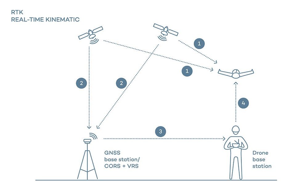
Real-Time Kinematic (RTK) is a precise positioning technology used in surveying, construction, agriculture, and other fields requiring high-accuracy location data. RTK improves the accuracy of standard Global Navigation Satellite Systems (GNSS) by using a stationary base station and one or more mobile receivers. Here’s a detailed explanation of how RTK works:
1. System Components
- Base Station: A stationary receiver placed at a known, fixed location. The base station continuously receives GNSS signals and calculates corrections based on its known position.
- Rover: One or more mobile receivers that move and collect data in the field. Rovers use the correction data from the base station to determine their precise position.
- Communication Link: A data link (radio, cellular, or internet) that transmits correction data from the base station to the rover(s) in real-time.
2. GNSS Signal Reception
- Base Station: The base station receives signals from multiple GNSS satellites, such as GPS, GLONASS, Galileo, or BeiDou.
- Rover: The rover also receives signals from the same GNSS satellites, determining its position relative to these satellites.
3. Error Calculation and Correction
- Base Station Processing: The base station calculates its position based on the GNSS signals and compares it to its known, fixed position. The difference between the calculated position and the known position represents the error in the GNSS signals.
- Correction Data Generation: The base station generates correction data for each satellite signal, which accounts for various errors such as satellite clock errors, atmospheric delays, and orbital inaccuracies.
4. Real-Time Data Transmission
- Communication Link: The base station transmits the correction data to the rover(s) via a communication link. This can be a radio signal, cellular network, or internet connection, depending on the system configuration and range requirements.
5. Rover Position Calculation
- Receiving Corrections: The rover receives the correction data from the base station in real-time.
- Applying Corrections: The rover applies the correction data to its own GNSS measurements, adjusting for the calculated errors.
- Precise Position Determination: By applying these corrections, the rover calculates its position with centimeter-level accuracy, significantly improving over the standard GNSS accuracy of several meters.
6. Applications and Use Cases
- Surveying and Mapping: RTK is widely used in land surveying and topographic mapping to achieve highly accurate measurements of land features and boundaries.
- Construction: RTK is used in construction projects for site preparation, machine control, and ensuring the precise placement of structures and utilities.
- Agriculture: RTK enables precision farming techniques, such as automated tractor guidance, variable rate application of fertilizers and pesticides, and accurate planting and harvesting.
- Geospatial Data Collection: RTK is used in various geospatial data collection applications, including environmental monitoring, urban planning, and infrastructure management.
- Marine and Aerial Surveying: RTK is used in hydrographic surveys, drone mapping, and other applications requiring high-precision positioning over water and from the air.
7. Advantages and Challenges
- Advantages:
- High Accuracy: RTK provides centimeter-level positioning accuracy, which is essential for applications requiring precise measurements.
- Real-Time Processing: RTK delivers real-time position corrections, allowing immediate use of accurate data in the field.
- Versatility: RTK can be used across various industries and applications, from agriculture to construction to surveying.
- Challenges:
- Line-of-Sight Requirements: The communication link between the base station and rover often requires a clear line of sight, especially for radio-based systems.
- Range Limitations: The effective range of RTK is limited by the communication method used. For example, radio links typically have a range of several kilometers, while cellular or internet-based systems can extend much further.
- Setup Complexity: Establishing a base station and ensuring a reliable communication link can be complex and may require technical expertise.
8. Technological Advances
- Network RTK (NRTK): Network RTK uses multiple base stations to create a network that provides correction data over a larger area, improving accuracy and reliability.
- Hybrid Positioning Systems: Combining RTK with other positioning technologies, such as inertial measurement units (IMUs), enhances accuracy and reliability in challenging environments.
- RTK on Drones and Mobile Devices: The integration of RTK technology into drones and mobile devices expands its applications in various fields, offering high-precision positioning for aerial surveys and mobile mapping.
Understanding how Real-Time Kinematic (RTK) works highlights its critical role in achieving high-precision positioning for various applications. By using a base station to provide real-time corrections to mobile rovers, RTK significantly improves the accuracy of GNSS, enabling precise measurements and operations in surveying, construction, agriculture, and other fields.
Example in Use
“Using RTK technology, the drone achieved centimeter-level accuracy in mapping the construction site, ensuring precise measurements and detailed topographical data.”
Frequently Asked Questions about RTK (Real-Time Kinematic)
1. How does RTK enhance GPS accuracy for drones?
Answer: RTK enhances GPS accuracy by using a fixed base station to receive satellite signals and calculate precise corrections. These corrections are transmitted to the drone’s mobile receiver, refining its position data to achieve centimeter-level accuracy. This process significantly reduces positional errors compared to standard GPS, which is crucial for high-precision applications.
2. Why is RTK important for drone operations?
Answer: RTK is important for drone operations because it:
- Enhances Precision: Provides high-accuracy positioning, essential for applications like mapping and surveying.
- Improves Data Quality: Ensures that the geospatial data collected is accurate and reliable.
- Supports Complex Tasks: Enables drones to perform detailed and precise tasks, such as infrastructure inspections and precision agriculture.
- Reduces Errors: Minimizes positional errors, improving the overall effectiveness of drone operations.
3. What are the applications of RTK in drone operations?
Answer: Applications of RTK in drone operations include:
- Mapping and Surveying: Achieving high-precision georeferencing for topographical maps and land surveys.
- Precision Agriculture: Enhancing the accuracy of crop monitoring, irrigation planning, and field mapping.
- Construction and Infrastructure: Providing detailed measurements and inspections of construction sites, roads, bridges, and other infrastructure.
- Environmental Monitoring: Conducting accurate surveys of natural habitats, forests, and water bodies for environmental studies.
For examples of these acronyms visit our Industries page.
As the CEO of Flyeye.io, Jacob Stoner spearheads the company's operations with his extensive expertise in the drone industry. He is a licensed commercial drone operator in Canada, where he frequently conducts drone inspections. Jacob is a highly respected figure within his local drone community, where he indulges his passion for videography during his leisure time. Above all, Jacob's keen interest lies in the potential societal impact of drone technology advancements.


