- Acronym Guide
- AAM
- ABS
- AC
- ACAS
- ADS-B
- AFAC
- AGL
- AI
- AIM
- ALS
- AM
- AMA
- ANSP
- AOI
- APPI
- AUV
- AUVSI
- ARPAS-UK
- ASTM
- ATC
- BVLOS
- CAA
- CAAC
- CAB
- CASA
- CATT
- CBO
- CBR
- CBRN
- CDMA
- CDR
- CFR
- CIR
- COA
- COMINT
- CORS
- COTP
- COTR
- CPTED
- CV
- C2
- DAA
- DEM
- DFI
- DFS
- DGCA
- DHS
- DOD
- DPA
- DPEs
- DRG
- DRO
- DSM
- DSMX
- DSP
- DSSS
- DTM
- EASA
- EFT
- EO
- EOD
- EO/IR
- ELINT
- EMI
- ESC
- EVLOS
- eVTOLs
- FAA
- FCC
- FCS
- FHSS
- FICCI
- FLIR
- FOB
- FOV
- FPS
- FPV
- GBDAA
- GCP
- GCS
- GDPR
- GML
- GNSS
- GPS
- GSD
- GVC
- HDR
- HOGE
- IACRA
- ICAO
- ICS
- IMU
- INS
- IR
- ISA
- ISR
- ITU
- JARUS
- LAAMS
- LAANC
- LAATM
- LAI
- LBA
- LIDAR
- LOS
- LSALT
- MAC
- MAVLink
- MLIT
- MMS
- MSL
- MTOM
- NDAA
- NCSL
- NFZ
- NIST
- NMEA
- NOTAM
- NPA
- NPRM
- NTIA
- OBIA
- OEM
- OFDM
- OOP
- PASM
- PAV
- PCV
- PdM
- PEC
- PIC
- PID
- PIPL
- PLD
- PM
- PN
- PPK
- PPS
- PSM
- PWM
- UAM
- UAOP
- UAS
- UASTM
- UAV
- UCAVs
- UHD
- UHF
- USV
- UTM
- RAIM
- RCC
- RCS
- RFI
- ReOC
- RePL
- RMS
- ROI
- RPAS
- RPC
- RTH
- RTK
- SaR
- SAR
- SARP
- SBAS
- S.Bus
- SBIR
- SEDENA
- SfM
- SFOC
- SIGINT
- SLAM
- SMS
- SORA
- STANAG
- STTR
- sUAS
- TCAS
- TCCA
- TFR
- TIN
- TOF
- TP
- TPS
- TSA
- VHF
- VLOS
- VTOL
Drone Acronyms
What is LAAMS (Low Altitude Air Management System)?
By
Jacob StonerTable Of Contents
Definition
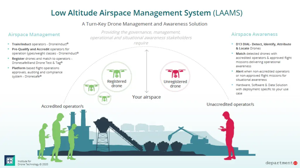
LAAMS stands for Low Altitude Air Management System. It is a framework designed to manage and regulate the use of airspace at lower altitudes, typically below 400 feet, where most drone operations occur. The system is intended to ensure the safe and efficient integration of drones into the national airspace by providing real-time information, traffic management, and regulatory enforcement for low-altitude operations.
Usage
LAAMS is used to coordinate the activities of various drones and other low-altitude airspace users, such as helicopters and small aircraft, to prevent collisions, manage air traffic, and enforce airspace restrictions. It provides drone operators with information about airspace conditions, such as temporary flight restrictions, weather, and other relevant data, allowing for safer and more compliant operations.
Relevance to the Industry
As the number of drones operating in low-altitude airspace increases, the need for effective management systems like LAAMS becomes critical. LAAMS plays a vital role in ensuring that drones can operate safely alongside manned aircraft and other airspace users. It is particularly relevant for commercial drone operators who need to navigate complex airspaces, comply with regulations, and avoid restricted areas.
How Does the Low Altitude Air Management System (LAAMS) Work?
System Integration and Data Collection:
- Real-Time Data Integration:
- Data Sources: LAAMS integrates data from multiple sources, including ground-based radar, satellite systems, ADS-B (Automatic Dependent Surveillance-Broadcast) signals, and other tracking technologies. This data provides comprehensive situational awareness of low-altitude airspace, allowing for real-time monitoring of both manned and unmanned aircraft.
- Airspace Users: The system monitors various airspace users, including drones, helicopters, and small aircraft, ensuring that all activities in low-altitude airspace are tracked and managed effectively.
- Data Processing and Analysis:
- Traffic Management Algorithms: LAAMS employs advanced algorithms to process the collected data, identifying potential conflicts between airspace users and suggesting optimal flight paths. These algorithms are designed to handle the dynamic nature of low-altitude airspace, where numerous aircraft may operate simultaneously in close proximity.
- Geofencing and Alerts: The system includes geofencing capabilities, which define virtual boundaries in the airspace. If a drone approaches a restricted or hazardous area, LAAMS generates alerts and automatically adjusts the drone’s flight path to avoid entering these areas.
Operational Coordination:
- Unmanned Traffic Management (UTM) Integration:
- Seamless Coordination: LAAMS often operates in conjunction with Unmanned Traffic Management (UTM) systems. While UTM focuses specifically on managing drone traffic, LAAMS provides broader coverage by coordinating all low-altitude airspace users. This integration ensures that manned and unmanned aircraft can safely coexist in the same airspace.
- Automated Communication: LAAMS facilitates automated communication between drones and other airspace users, reducing the need for human intervention and enabling more efficient air traffic management. This is particularly important in high-density areas or during complex operations, such as emergency response.
- Air Traffic Control (ATC) Collaboration:
- Supporting ATC Operations: LAAMS provides real-time data to traditional Air Traffic Control (ATC) systems, allowing controllers to monitor low-altitude airspace and ensure that drone operations do not interfere with manned aircraft. This collaboration helps maintain overall airspace safety and efficiency.
- Dynamic Airspace Management: The system enables dynamic airspace management, allowing for the rapid reconfiguration of airspace boundaries based on real-time traffic conditions. This flexibility is crucial for accommodating diverse airspace users and responding to unexpected changes, such as emergency flights or temporary flight restrictions.
Regulatory Compliance and Safety Enforcement:
- Regulation Enforcement:
- Compliance Monitoring: LAAMS continuously monitors drone operations to ensure compliance with regulatory requirements, such as altitude limits, no-fly zones, and operational restrictions. The system automatically detects any violations and can take corrective actions, such as rerouting drones or alerting operators.
- Incident Reporting: In the event of an airspace violation or potential collision, LAAMS logs the incident and provides detailed reports to relevant authorities. These reports help with the investigation of incidents and the improvement of safety protocols.
- User Interface and Accessibility:
- Operator Tools: LAAMS offers user-friendly interfaces that provide drone operators with real-time information about airspace conditions, potential conflicts, and flight path recommendations. These tools are accessible via mobile apps, web platforms, and integrated flight control systems, ensuring that operators can easily access the information they need to conduct safe and compliant operations.
- Public Awareness: The system also includes features for public awareness, allowing non-aviation users to understand airspace restrictions and safety protocols, particularly in urban areas where drone activity is high.
Advanced Features:
- Weather Integration:
- Real-Time Weather Updates: LAAMS integrates real-time weather data into its management system, providing operators with information about wind speed, temperature, precipitation, and other weather conditions that could affect drone operations. This helps operators plan safer and more efficient flights.
- Predictive Analysis: The system uses predictive analytics to anticipate weather changes and adjust flight paths accordingly, minimizing the risk of weather-related incidents.
- Scalability and Adaptability:
- Scalable Architecture: LAAMS is designed to be scalable, capable of managing increasing numbers of drones and other airspace users as the demand for low-altitude airspace grows. The system can adapt to varying levels of traffic density and operational complexity, from rural areas with low activity to urban environments with high traffic volumes.
- Continuous Improvement: LAAMS is continuously updated with new technologies, regulations, and operational best practices to ensure it remains effective in managing the evolving landscape of low-altitude airspace.
By integrating real-time data, facilitating coordination between different airspace users, enforcing regulations, and providing accessible tools for operators, the Low Altitude Air Management System (LAAMS) plays a crucial role in ensuring the safe and efficient use of low-altitude airspace, particularly as drone operations continue to expand.
Example in Use
“The drone operator used the Low Altitude Air Management System (LAAMS) to plan their flight path, ensuring they avoided restricted airspace and complied with all safety regulations.”
Frequently Asked Questions about LAAMS (Low Altitude Air Management System)
1. How does LAAMS improve safety for drone operations?
Answer: LAAMS improves safety for drone operations by:
- Providing Real-Time Information: LAAMS delivers real-time data about airspace conditions, including the location of other aircraft, temporary flight restrictions, and weather conditions. This helps drone operators make informed decisions and avoid potential hazards.
- Managing Traffic: The system coordinates the activities of multiple drones and other low-altitude airspace users to prevent collisions and ensure orderly air traffic flow.
- Enforcing Regulations: LAAMS helps enforce airspace regulations by monitoring drone activities and ensuring compliance with altitude limits, no-fly zones, and other restrictions.
2. What types of operations benefit most from LAAMS?
Answer: Operations that benefit most from LAAMS include:
- Commercial Drone Operations: LAAMS is particularly useful for commercial drone operators conducting tasks such as aerial photography, surveying, and delivery services. It helps them navigate busy or complex airspace environments safely and efficiently.
- Emergency Response: LAAMS can be critical during emergency response operations, where drones need to operate in coordination with manned aircraft, such as helicopters, to provide real-time data and situational awareness.
- Urban Air Mobility: As urban air mobility (UAM) becomes more prevalent, with drones and air taxis operating in close proximity to each other and to buildings, LAAMS will be essential for managing these operations safely.
3. How is LAAMS integrated with other air traffic management systems?
Answer: LAAMS is integrated with other air traffic management systems by:
- Interfacing with UTM (Unmanned Traffic Management): LAAMS often works in conjunction with UTM systems, which are designed to manage drone traffic specifically. Together, they provide comprehensive coverage of low-altitude and unmanned airspace.
- Collaboration with ATC (Air Traffic Control): LAAMS provides data to traditional air traffic control systems, allowing controllers to monitor low-altitude airspace and ensure that drone operations do not interfere with manned aircraft.
- Supporting National Airspace Management: LAAMS is part of a broader national airspace management strategy that aims to integrate all types of airspace users, from commercial airlines to recreational drones, into a unified system.
For examples of these acronyms visit our Industries page.
As the CEO of Flyeye.io, Jacob Stoner spearheads the company's operations with his extensive expertise in the drone industry. He is a licensed commercial drone operator in Canada, where he frequently conducts drone inspections. Jacob is a highly respected figure within his local drone community, where he indulges his passion for videography during his leisure time. Above all, Jacob's keen interest lies in the potential societal impact of drone technology advancements.


