AGL (Above Ground Level)
Definition
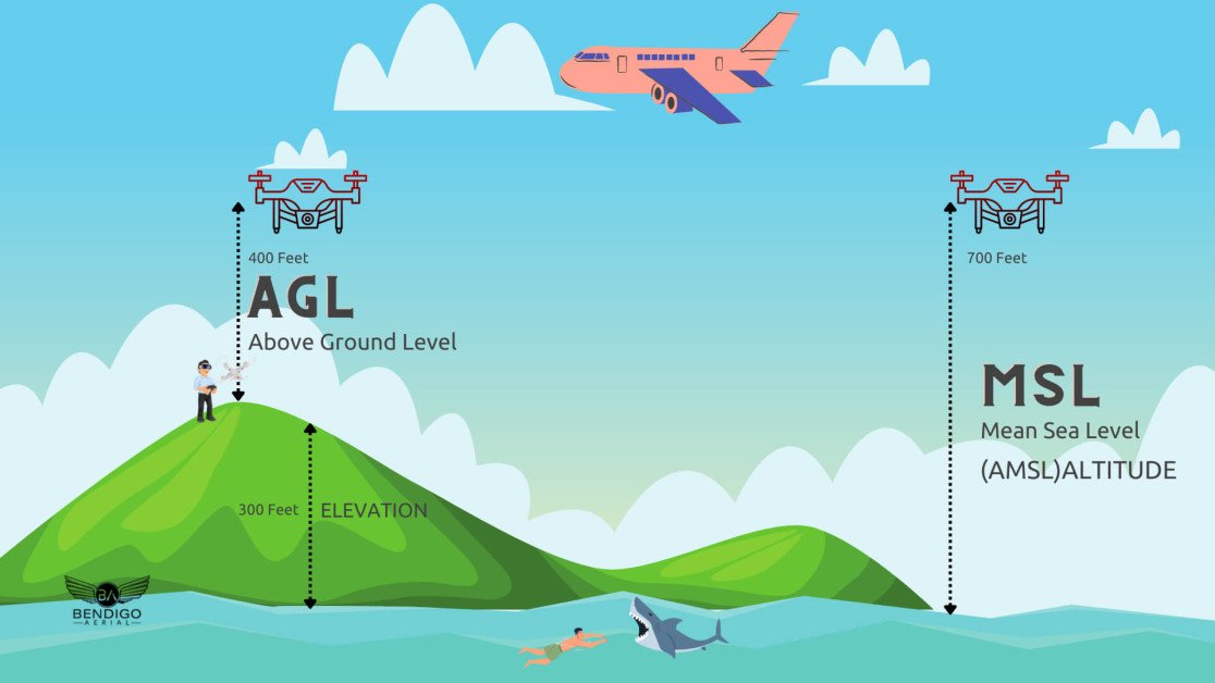
AGL stands for Above Ground Level. It is a term used to describe the altitude or height of an object, such as a drone or aircraft, measured from the ground directly below it. AGL is an important metric in aviation to ensure safe and precise altitude management.
Relevance to the Industry
Understanding and using AGL is essential for safe and effective drone operations. It ensures that drones maintain a safe distance from the ground and obstacles, preventing collisions and enhancing operational accuracy. AGL is particularly important in industries like agriculture, construction, and environmental monitoring, where drones often operate close to the ground.
How Does Above Ground Level (AGL) Work?
Above Ground Level (AGL) is a measurement of an object's altitude or height relative to the ground directly beneath it. This term is commonly used in aviation, surveying, and meteorology to provide clear and practical altitude references. Here’s a detailed explanation of how it works:
1. System Components
- Altimeters: Devices used to measure altitude. There are different types of altimeters, including barometric altimeters, radar altimeters, and GPS-based altimeters.
- Ground Reference: The point on the ground directly below the object, which serves as the reference level for AGL measurements.
- Measurement Units: Altitude is typically measured in feet or meters above the ground level.
2. Types of Altimeters
- Barometric Altimeter: Measures altitude based on atmospheric pressure. Since air pressure decreases with height, the altimeter calculates altitude by comparing the current air pressure to a standard atmospheric model.
- Calibration: Needs to be calibrated to the local sea-level pressure to ensure accurate readings.
- Radar Altimeter: Uses radio waves to measure the distance between the aircraft and the ground. It sends a radio signal downwards and measures the time it takes for the signal to bounce back from the ground.
- Precision: Provides highly accurate and real-time altitude readings, especially useful during takeoff and landing.
- GPS Altimeter: Uses signals from GPS satellites to calculate altitude. By determining the exact position in three-dimensional space, the GPS system can provide altitude data relative to the ground level.
- Global Reference: Offers consistent altitude measurements regardless of local atmospheric conditions.
3. Measurement Process
- Initialization: The altimeter is initialized at a known ground level, often during pre-flight checks for aircraft or at the starting point of a survey.
- Real-Time Data Collection: During flight or operation, the altimeter continuously measures altitude and adjusts for changes in ground elevation.
- Altitude Calculation: The device calculates the altitude above ground level by factoring in the distance from the reference ground point directly beneath the object.
4. Data Interpretation
- Altitude Readouts: The measured AGL altitude is displayed on the aircraft's instruments or the surveying equipment's interface. Pilots and operators monitor these readings to ensure safe operations.
- Altitude Alerts: Some systems provide alerts if the altitude drops below a pre-set minimum AGL threshold, enhancing safety, especially in low-visibility conditions or during low-altitude maneuvers.
5. Applications and Use Cases
- Aviation: Pilots use AGL measurements to ensure safe flight operations, particularly during takeoff, landing, and low-altitude flying. Accurate AGL readings help in obstacle avoidance and terrain awareness.
- Surveying and Mapping: Surveyors use AGL data to accurately map terrain features and construct topographic profiles. Drones equipped with AGL sensors provide precise altitude information for aerial surveys.
- Meteorology: Weather stations and research balloons use AGL measurements to monitor atmospheric conditions at various altitudes above the ground.
- Construction and Engineering: Engineers use AGL data to plan and execute construction projects, ensuring structures are built at the correct elevations relative to the ground.
6. Advantages and Challenges
- Advantages: AGL provides a clear and practical reference for altitude relative to the ground, enhancing safety and precision in various fields. It helps pilots maintain safe distances from terrain and obstacles, and surveyors achieve accurate elevation measurements.
- Challenges: Barometric altimeters require constant calibration to account for changes in atmospheric pressure. Radar altimeters may be affected by terrain irregularities, and GPS altimeters rely on the availability and accuracy of satellite signals.
Understanding how Above Ground Level (AGL) works highlights its critical role in aviation, surveying, meteorology, and other fields that require precise altitude measurements relative to the ground. By utilizing different types of altimeters and real-time data collection, AGL provides essential information for safe and accurate operations across various applications.
Example in Use
“The drone maintained an altitude of 100 feet AGL during the survey to ensure accurate data collection and avoid obstacles.”
Frequently Asked Questions about AGL (Above Ground Level)
1. What is AGL and why is it important for drone operations?
Answer: AGL (Above Ground Level) refers to the altitude of an object measured from the ground directly beneath it. It is important for drone operations because it provides a precise measurement of how high the drone is flying relative to the terrain below. This is crucial for maintaining safe altitudes, avoiding obstacles, and ensuring compliance with regulatory height restrictions.
2. How is AGL different from MSL (Mean Sea Level)?
Answer: AGL (Above Ground Level) measures altitude relative to the ground directly beneath the object, while MSL (Mean Sea Level) measures altitude relative to the average sea level. AGL is used for operations requiring precise altitude control relative to the terrain, whereas MSL is used for navigation and aviation charts where altitude relative to sea level is more relevant.
3. What are the practical applications of AGL in drone operations?
Answer: Practical applications of AGL in drone operations include:
- Low-Altitude Inspections: Performing detailed inspections of infrastructure, such as bridges and power lines, at specific heights above the ground.
- Agricultural Monitoring: Flying at precise altitudes to monitor crop health and perform tasks like spraying fertilizers and pesticides.
- Aerial Photography and Videography: Capturing images and videos at specific heights to achieve desired perspectives and avoid obstacles.
- Environmental Surveys: Conducting wildlife monitoring and habitat assessments at altitudes that minimize disturbance to the environment.
For examples of these acronyms visit our Industries page.