- Guide
- Flight in High Winds
- How to Choose Your First Drone
- How to Fly a Drone for Beginners
- Insurance Guide
- Maximize Performance
- Maintenance Tips
- Optimize Flight Time
- Optimize Payload Capacity
- Part 107 & RPAS How to Guide
- Understanding Drone Terminology
- Understanding FAA Drone Regulations
- Safety Guidelines
- Surveying Guide
Top Guides
Understanding Drone Terminology
By
Jacob StonerTable Of Contents

Fly smart and stay safe out there! Interested in understanding drone terminology? Discover free resources to learn the basics here. Ready to earn your FAA commercial drone certificate? Start preparing today right here.
Understanding Drone Terminology For beginners
Drones are revolutionizing industries, hobbies, and emergency responses, but understanding drone terminology can be daunting. Whether you’re a beginner exploring your first drone or an industry professional using drones for advanced applications, grasping the key terms is essential for safe and effective operation. This guide breaks down drone-related jargon into clear, accessible definitions, helping you build confidence and fluency in this rapidly evolving field.
Article Guide
- Basic Terms
- Flight and Navigation
- Regulatory Terms
- Hardware Components
- Technical Jargon
- Camera and Imaging Terms
- Advanced and Emerging Terms
- Conclusion
1. Understanding Drone Terminology- Basic Terms

Drone/UAV (Unmanned Aerial Vehicle)
A drone is a broad term for any aircraft that can operate without an onboard human pilot. While “drone” is the popular term, the technical term “UAV” (Unmanned Aerial Vehicle) is often used in professional and regulatory contexts. Drones come in various forms, from small recreational models to large industrial systems.
Multirotor
This is the most common type of drone, characterized by its multiple rotors (typically four, six, or eight). Multirotor drones are popular for their versatility, ease of use, and ability to hover in place, making them ideal for aerial photography, inspections, and short-range tasks.
Fixed-Wing Drone
Unlike multirotors, fixed-wing drones resemble traditional airplanes, using wings for lift. They are typically used for long-range and high-speed applications, such as mapping large areas or surveying. These drones cannot hover but are more energy-efficient for extended flights.
VTOL (Vertical Take-Off and Landing)
VTOL drones combine the features of fixed-wing and multirotor drones. They can take off and land vertically like a multirotor but transition into efficient forward flight like a fixed-wing aircraft. This makes them suitable for tasks requiring versatility, such as search and rescue.
RPAS (Remotely Piloted Aircraft System)
This is a regulatory term used interchangeably with “drone” or “UAV” in many countries. RPAS emphasizes the system as a whole, including the drone, its remote controller, and any associated equipment. Knowing this term is essential for understanding legal documents and certifications.
2. Understanding Drone Terminology- Flight and Navigation
Understanding Drone Hovering
Hovering refers to a drone’s ability to maintain a stable position in mid-air without moving in any direction. This is a fundamental feature of multirotor drones, achieved through precise control of the propellers. Hovering is critical for capturing detailed images or videos, conducting inspections, and practicing flight skills.
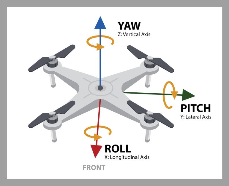
Understanding Drone Yaw, Pitch, and Roll
These terms describe the three axes of movement for a drone:
- Yaw: Rotating the drone left or right around its vertical axis. Useful for changing direction while keeping the camera focused.
- Pitch: Tilting the drone forward or backward along its horizontal axis, which allows it to move forward or backward.
- Roll: Tilting the drone sideways, enabling side-to-side movement.
Understanding these axes is essential for mastering drone flight control.
FPV (First-Person View)
FPV allows pilots to see what their drone sees in real-time, often through goggles or a screen on the remote controller. This immersive flying method is popular in drone racing and photography, offering precise control and situational awareness.
Understanding Drone Waypoint Navigation
Waypoint navigation involves programming a set of coordinates or locations for the drone to follow automatically. This feature is commonly used in professional applications like surveying, mapping, or delivery, where precise and repeatable routes are required.
Return to Home (RTH)
A safety feature that brings the drone back to its take-off point (or another pre-set location) automatically. RTH is triggered by the pilot or in emergencies, such as low battery or lost signal. It’s an invaluable tool for ensuring safe recovery of your drone.
Understanding Drone Altitude Hold
This feature enables a drone to maintain a consistent height above the ground without manual input from the pilot. It’s especially useful for beginners and for capturing stable aerial footage.
Understanding Drone Headless Mode
In headless mode, the drone’s orientation is relative to the pilot rather than the direction the drone is facing. This makes it easier for beginners to control, as they don’t have to worry about which direction the drone is pointing.
Understanding Drone GPS Lock
A GPS lock ensures the drone remains in a fixed position relative to its GPS coordinates, even in windy conditions. It is crucial for precise navigation and safe operations in outdoor environments.
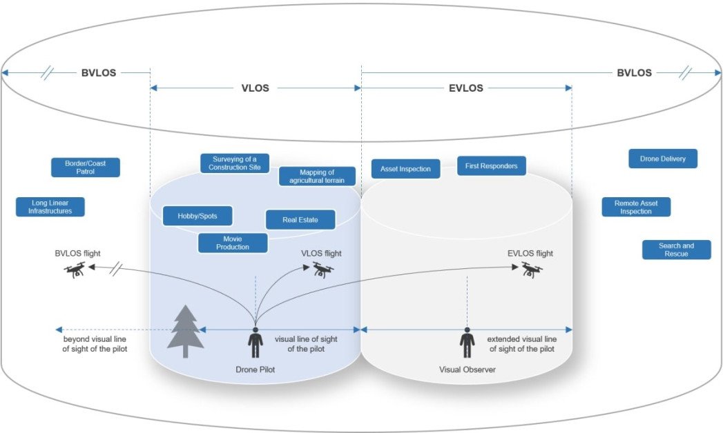
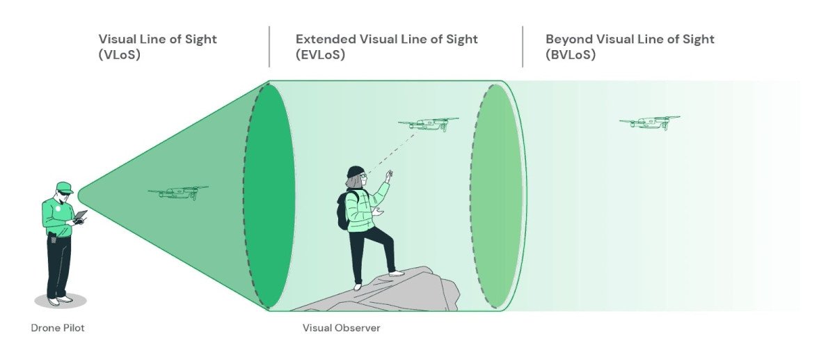
Visual Line of Sight (VLOS)
Flying within the operator’s visual line of sight (VLOS) means keeping the drone in view without using FPV systems. This is a regulatory requirement in many countries to ensure safe operations.
Understanding Drone Geofencing
Geofencing uses GPS to create virtual boundaries that restrict where a drone can fly. These zones are often implemented to prevent entry into restricted airspaces, such as airports or military areas. Pilots can often customize geofences to suit specific needs.
3. Understanding Drone Terminology- Regulatory Terms
No-Fly Zone (NFZ)
No-fly zones are designated areas where drone operations are restricted or prohibited. These include locations such as airports, military bases, national parks, and critical infrastructure sites. Most modern drones use geofencing technology to automatically prevent flights in these areas. Understanding NFZs is essential for safe and legal operations.
BVLOS (Beyond Visual Line of Sight)
BVLOS flights occur when a drone operates beyond the pilot’s direct line of sight. These operations require special permissions and certifications due to increased risks. BVLOS is often used in industrial applications like long-range inspections, delivery services, and environmental monitoring.
Understanding Drone Part 107 Certification (US)
In the United States, the Part 107 certification is a mandatory license for operating drones commercially. Administered by the FAA (Federal Aviation Administration), it requires passing a knowledge test covering topics such as airspace regulations, weather, and drone safety.
Understanding Drone Airspace Classes
Airspace is divided into different classes, each with specific rules for drone operations:
- Class A: High-altitude airspace where drones are not permitted.
- Class B, C, and D: Surround airports and require authorization for drone flights.
- Class G: Uncontrolled airspace where drones can typically fly without special permissions.
Understanding airspace classes helps operators avoid unauthorized flights and potential fines.
Understanding Drone Remote Identification (Remote ID)
Remote ID is a system that allows authorities to identify and track drones in real time. It acts as a digital license plate, providing information about the drone’s location, serial number, and operator. Compliance with Remote ID regulations is increasingly becoming mandatory in many countries.
Understanding Drone Operational Categories
Many countries classify drone operations into categories based on risk:
- Open Category: Low-risk flights with minimal regulations.
- Specific Category: Moderate-risk flights requiring operational authorization.
- Certified Category: High-risk operations, often involving larger drones or manned airspace integration.
These categories help ensure safety while accommodating diverse drone use cases.
Understanding Drone Night Operations
Night operations refer to flying drones after sunset. Special permissions, additional lighting, and adherence to stricter safety protocols are often required to conduct flights legally at night. This is important for professionals involved in search and rescue, cinematography, or inspections.
Pilot-in-Command (PIC)
The Pilot-in-Command is the individual responsible for the operation of a drone during a flight. This term emphasizes accountability, ensuring that there is always one person in charge of safety, navigation, and compliance with regulations.
TFR (Temporary Flight Restriction)
TFRs are temporary restrictions on airspace, often implemented for events like VIP visits, sports events, or emergency situations. Drone operators must be aware of TFRs in their area to avoid accidental violations and potential penalties.

4. Understanding Drone Terminology- Hardware Components
Understanding Drone Propellers
Propellers are the spinning blades that generate lift and enable the drone to move. They work by displacing air downward, creating an upward force. The number and design of propellers vary by drone type, with most consumer drones using four. Proper maintenance, such as regular cleaning and balancing, is critical for smooth operation.
ESC (Electronic Speed Controller)
The ESC is a key component that manages the speed of the drone’s motors. It receives signals from the flight controller and adjusts motor speeds to achieve the desired movements, such as ascending, descending, or hovering. Damaged ESCs can result in erratic drone behavior or complete loss of control.
Understanding Drone Gimbal
A gimbal is a stabilization mechanism that keeps the drone’s camera steady during flight. Most modern drones use 3-axis gimbals to counteract yaw, pitch, and roll movements, ensuring smooth and level video footage even in windy conditions. Gimbals are essential for professional-grade aerial photography and videography.
Understanding Drone Payload
The payload refers to any equipment or cargo the drone carries in addition to its basic components. This can include cameras, thermal imaging sensors, delivery packages, or even medical supplies. The weight and type of payload significantly affect a drone’s performance, including its flight time and stability.
Understanding Drone Flight Controller
The flight controller is the brain of the drone, managing all systems and ensuring stable flight. It processes inputs from the pilot and sensors, making real-time adjustments to keep the drone airborne. Advanced flight controllers may also include features like GPS integration, waypoint navigation, and collision avoidance.
Understanding Drone Motors
Drone motors drive the propellers and come in two types: brushed and brushless.
- Brushed Motors: Affordable and simpler but less durable.
- Brushless Motors: More efficient, quieter, and long-lasting, commonly found in high-quality drones.
Well-maintained motors are crucial for consistent performance.
Understanding Drone Landing Gear
Landing gear protects the drone’s body and camera during take-off and landing. Some drones have fixed landing gear, while others feature retractable systems to reduce drag and improve aerodynamics. Properly designed landing gear minimizes impact damage.
Understanding Drone Battery and Power System
The battery is the drone’s energy source, usually lithium-polymer (LiPo) for its high energy density. Proper battery care, including avoiding overcharging or deep discharges, extends its lifespan. Some drones include smart batteries that monitor charge levels and provide warnings for low power.
Understanding Drone Camera
Many drones are equipped with cameras for capturing aerial photos and videos. Camera specifications vary widely, with features like 4K resolution, optical zoom, and thermal imaging. High-end cameras often include adjustable settings for aperture, shutter speed, and ISO to achieve professional-quality footage.
Understanding Drone Sensors
Sensors enhance a drone’s capabilities by providing critical data for navigation and stability. Common types include:
- GPS Sensors: Enable precise positioning and waypoint navigation.
- Obstacle Avoidance Sensors: Use ultrasonic, infrared, or visual technology to detect and avoid obstacles.
- Barometers: Measure air pressure to determine altitude.
Understanding Drone Antenna
Drones use antennas to communicate with the controller and receive GPS signals. Signal quality affects range and responsiveness, so maintaining a clear, unobstructed line between the drone and its controller is essential.
Understanding Drone Frame
The frame is the skeleton of the drone, holding all components together. Frames can be made from materials like plastic, carbon fiber, or aluminum. Carbon fiber frames are lightweight yet durable, making them ideal for high-performance drones.
5. Understanding Drone Terminology- Technical Jargon
Telemetry
Telemetry refers to the real-time data transmitted from the drone to its ground station or controller. This data typically includes altitude, speed, GPS coordinates, battery level, and signal strength. Telemetry is critical for monitoring a drone’s performance and ensuring safe operation, especially during long-range flights.
Firmware
Firmware is the software embedded in a drone’s hardware that controls its basic functions. Manufacturers frequently release firmware updates to improve performance, fix bugs, and add new features. Regular updates ensure compatibility with accessories and compliance with regulatory changes.
Geofencing
Geofencing is a virtual boundary set using GPS technology to restrict where a drone can fly. Manufacturers implement geofencing to prevent entry into restricted zones, such as airports or military areas. Operators can often customize geofences for safety or operational needs.
Understanding Drone Flight Modes
Drones offer various flight modes to suit different skill levels and tasks:
- GPS Mode: Provides precise positioning and stability using satellite data.
- ATTI Mode (Attitude Mode): Disables GPS stabilization, requiring manual control. Useful for experienced pilots in windy conditions.
- Manual Mode: Offers complete control without stabilization, often used for aerobatics or racing.
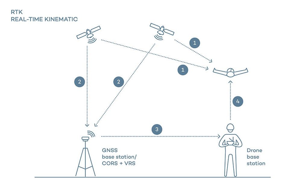
RTK (Real-Time Kinematics)
RTK is an advanced GPS technology that enhances positioning accuracy to within centimeters. It is commonly used in industries like surveying, mapping, and precision agriculture, where high-accuracy data is essential.
Failsafe
Failsafe mechanisms are automated responses triggered by events like signal loss or low battery. For example, the drone may initiate a Return to Home (RTH) or land safely to prevent crashes. These features are essential for minimizing risks during operation.
Understanding Drone Latency
Latency is the delay between the transmission of a command from the controller and the drone’s response. Low latency is critical for applications requiring precise and immediate inputs, such as racing or filming fast-moving subjects.
PID (Proportional-Integral-Derivative) Tuning
PID tuning is a method used to adjust a drone’s flight controller for optimal performance. It involves fine-tuning how the drone responds to inputs and environmental conditions, ensuring smooth and stable flight.
Understanding Drone Obstacle Avoidance
Obstacle avoidance systems use sensors like ultrasonic, infrared, or cameras to detect and avoid potential collisions. Advanced drones integrate AI to predict and navigate around obstacles in real time, enhancing safety in complex environments.
Flight Logs
Flight logs are records of a drone’s operational data, including routes, altitudes, and speeds. These logs are useful for performance analysis, troubleshooting, and meeting regulatory compliance, especially in commercial applications.
Dynamic Range
Dynamic range in drone cameras refers to the ability to capture details in both bright and dark areas simultaneously. High dynamic range (HDR) improves image quality, making it particularly useful for photography in challenging lighting conditions.
Compass Calibration
Compass calibration is a process to ensure the drone’s navigation system works accurately. It involves aligning the drone’s internal compass with the Earth’s magnetic field. Calibration is necessary to avoid navigation errors, especially before flying in new locations.
Jello Effect
The jello effect is a visual distortion in videos caused by vibrations transmitted to the camera. This effect is common in drones without proper stabilization or poorly balanced propellers. Gimbals and vibration-dampening features help mitigate this issue.
Waypoint Mission
Waypoint missions involve programming a series of GPS coordinates that a drone will follow automatically. This feature is widely used in tasks like surveying, inspections, and mapping, where precision and repeatability are critical.
Ground Station
A ground station is the control interface for drones, often a combination of hardware and software. It allows pilots to monitor telemetry, plan missions, and make adjustments in real time. Ground stations are essential for professional operations.
FPV Latency
FPV latency refers specifically to the delay between a drone’s camera feed and its display in goggles or screens. Lower latency ensures smoother and more responsive FPV flying, which is vital for racing and cinematic shots.
6. Understanding Drone Terminology- Camera and Imaging Terms
Aperture, Shutter Speed, ISO
These are the three core settings of a drone camera, forming the “exposure triangle.”
- Aperture: Controls the amount of light entering the camera by adjusting the size of the lens opening. A wider aperture (lower f-stop number) lets in more light but reduces depth of field.
- Shutter Speed: Determines how long the camera sensor is exposed to light. Faster shutter speeds freeze motion, while slower speeds create motion blur.
- ISO: Adjusts the camera’s sensitivity to light. A higher ISO brightens images but may introduce noise.
ND Filters
Neutral Density (ND) filters are like sunglasses for your camera lens, reducing the amount of light entering the sensor. They allow for better control of shutter speed in bright conditions, enabling smoother motion in videos or more balanced exposures in photos.
GSD (Ground Sampling Distance)
GSD is a metric that measures the distance between two pixels in an image, calculated on the ground. Lower GSD values indicate higher resolution, which is crucial for detailed mapping and surveying applications.
Understanding Drone Thermal Imaging
Thermal imaging cameras detect infrared radiation, converting it into temperature-based images. These are commonly used for applications like search and rescue, building inspections, and agricultural monitoring. Thermal cameras can detect heat leaks, hotspots, or even locate people in low-visibility conditions.
HDR (High Dynamic Range)
HDR combines multiple exposures of the same shot to create a single image with enhanced details in both bright and dark areas. This technique is particularly useful for capturing landscapes or high-contrast scenes, resulting in more visually striking images.
Optical Zoom vs. Digital Zoom
- Optical Zoom: Uses the physical movement of the camera lens to magnify the image without losing quality.
- Digital Zoom: Enlarges the image digitally, often resulting in a loss of resolution.
Drones with optical zoom are preferred for professional tasks requiring close-ups, such as inspections or surveillance.
Stitching
Image stitching is the process of combining multiple photos to create a single, seamless image, often used in mapping and panoramic photography. Specialized software or onboard drone technology automates this task for high-quality results.
FPS (Frames Per Second)
FPS determines the smoothness of video playback. Higher FPS values, like 60 or 120, are ideal for capturing fast-moving subjects or creating slow-motion effects. Most drones offer adjustable FPS settings based on the resolution.
Field of View (FOV)
FOV refers to the extent of the scene captured by the drone’s camera, measured in degrees. A wider FOV captures more of the surroundings, while a narrower FOV focuses on specific details. Wide-angle lenses are commonly used for expansive aerial shots.
Panorama Mode
Some drones feature a panorama mode, which automatically captures a series of images and stitches them together to create wide-angle or 360-degree photos. This mode is popular for scenic landscapes and immersive content.
Photogrammetry
Photogrammetry involves taking overlapping aerial photos of an area and using software to generate 3D models or maps. It’s a key application for industries like construction, agriculture, and surveying, requiring high-resolution imaging.
Bitrate
Bitrate refers to the amount of data processed per second in a video. Higher bitrates result in better video quality but require more storage space. For drones, a higher bitrate is crucial for capturing detailed and professional-grade footage.
Color Grading
Color grading is the process of adjusting the colors and tones of a video to achieve a specific aesthetic or mood. Professional drones often capture video in flat profiles like D-Log, providing more flexibility for post-production grading.
Resolution
Resolution determines the clarity of photos and videos captured by a drone. Common resolutions include Full HD (1080p), 4K, and even 8K for high-end models. Higher resolution is ideal for professional use, while lower resolution is sufficient for casual photography.
RAW Format
RAW is an uncompressed image format that retains all the data captured by the camera sensor. This format allows for extensive editing flexibility in post-production, making it the preferred choice for professional photographers and videographers.
Overexposure Warning
Many drone cameras include an overexposure warning (often displayed as zebra stripes) to indicate areas of an image that are too bright. Adjusting the exposure settings ensures better image quality.
7. Understanding Drone Terminology- Advanced and Emerging Terms
AI-Powered Drones
AI-powered drones leverage artificial intelligence to perform tasks autonomously or with minimal human input. AI capabilities include object detection, path planning, and dynamic obstacle avoidance. These drones are transforming industries like delivery, surveillance, and disaster response by improving efficiency and safety.
Swarming
Swarming refers to the coordinated operation of multiple drones working together as a single unit. This technology is inspired by natural systems, such as bird flocks or bee swarms, and is used for applications like search and rescue, agriculture, or military operations.
Autonomous Flight
Autonomous flight enables drones to operate without manual control, relying on pre-programmed instructions or AI algorithms. This is achieved through advanced sensors, GPS, and onboard computers. Autonomous drones are widely used in delivery services, large-scale inspections, and mapping.
Understanding Drone Collision Avoidance
Collision avoidance systems use sensors like ultrasonic, infrared, or cameras to detect and avoid obstacles in real time. Advanced drones integrate AI and machine learning to predict potential collisions and take corrective actions, ensuring safe operations even in complex environments.
Drone-in-a-Box
A drone-in-a-box system includes a drone housed in an automated docking station, which handles take-offs, landings, and recharging. These systems are ideal for continuous operations like security monitoring, agriculture, or environmental surveys, where manual intervention is minimal.
3D Mapping and Modeling
Drones equipped with high-resolution cameras or LiDAR sensors create detailed 3D models of landscapes, buildings, or structures. These models are used in urban planning, construction, and environmental monitoring, offering precise visualizations and measurements.
LiDAR (Light Detection and Ranging)
LiDAR is a remote sensing method that uses laser pulses to measure distances and generate highly accurate 3D maps. It’s particularly useful in forestry, archaeology, and infrastructure inspection, where precision is paramount.

Blockchain in Drone Operations
Blockchain technology is emerging as a way to secure and streamline drone operations. It can be used for tracking drone flights, verifying payloads, and ensuring compliance with regulations. This technology enhances transparency and trust in commercial drone applications.
Edge Computing
Edge computing allows drones to process data locally rather than relying on cloud servers. This reduces latency and enables real-time decision-making for tasks like obstacle avoidance or video analysis. Edge computing is vital for autonomous and AI-driven drones.
Remote ID
Remote ID acts as a digital license plate for drones, transmitting information like the drone’s identity, location, and operator details to authorities. This technology enhances airspace security and compliance, especially as drone traffic increases.
Thermal Drones
Thermal drones use infrared cameras to detect heat signatures, making them indispensable for applications like search and rescue, firefighting, and energy audits. Advanced thermal drones can even differentiate between heat sources, such as humans versus machinery.
Drone Delivery Networks
Drone delivery networks involve a system of interconnected drones working to transport goods efficiently. These networks are supported by AI algorithms, centralized logistics systems, and autonomous flight capabilities, making them a key component of the future of delivery services.
5G-Enabled Drones
Drones equipped with 5G connectivity benefit from faster data transfer and low-latency communication. This technology is essential for real-time video streaming, BVLOS operations, and coordinated drone swarms, significantly enhancing their capabilities.
Quantum Drones
An emerging concept, quantum drones leverage quantum technology for enhanced computation and communication. While still in the experimental phase, they have the potential to revolutionize data security, AI capabilities, and performance in complex environments.
Smart Sensors
Smart sensors go beyond traditional data collection, integrating AI to analyze and act on data in real time. These sensors can optimize drone performance by adjusting for environmental conditions or detecting anomalies during inspections.
eVTOL (Electric Vertical Take-Off and Landing)
eVTOL aircraft combine the efficiency of fixed-wing drones with the versatility of multirotor designs. Powered by electric motors, these drones are being developed for urban air mobility, including passenger transport and large-scale deliveries.

Energy Harvesting Drones
Energy harvesting drones capture power from their environment, such as solar panels or wind turbines, to extend their flight time. This technology is being explored to enable longer missions and reduce reliance on traditional battery systems.
8. Understanding Drone Terminology- Conclusion
Understanding drone terminology is a vital step toward becoming a confident and informed drone operator. Whether you’re flying for fun, pursuing a professional career, or exploring cutting-edge drone technologies, knowing the language of drones empowers you to navigate this rapidly evolving industry with ease.
This guide is designed to serve as a foundation, helping you decode common terms, master technical concepts, and appreciate the advanced innovations shaping the future of drones. As you progress, continue exploring new terms and technologies to deepen your expertise and adapt to industry changes.
For beginners, this knowledge will demystify the complexities of drone operation, while professionals can use it as a refresher or reference tool. To further your journey, consider pairing this guide with practical experience, additional training, or certifications to solidify your skills and stay ahead in the world of drones.
Fly wisely, stay curious, and let this knowledge elevate your understanding of drones to new heights!
To Learn more about acronyms used in this article visit our Drones Acronym Page.
As the CEO of Flyeye.io, Jacob Stoner spearheads the company's operations with his extensive expertise in the drone industry. He is a licensed commercial drone operator in Canada, where he frequently conducts drone inspections. Jacob is a highly respected figure within his local drone community, where he indulges his passion for videography during his leisure time. Above all, Jacob's keen interest lies in the potential societal impact of drone technology advancements.