Definition ALPA stands for the Air Line Pilots Association, the largest airline pilot union in the world. It represents over 60,000 pilots in the United States...
Definition AEHF stands for Advanced Extremely High Frequency, a secure satellite communication system operating in the 30–300 GHz range. Originally developed for military use, AEHF systems provide...
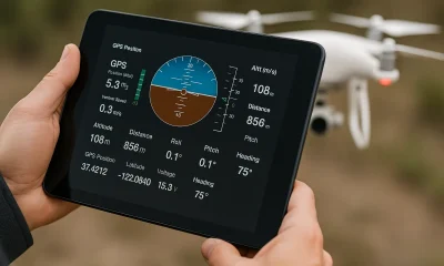
Definition TLM stands for Telemetry, which refers to the real-time transmission of data from a drone to a ground control system. This data includes critical flight...
Definition PTZ stands for Pan-Tilt-Zoom, a camera system that can rotate left and right (pan), move up and down (tilt), and magnify subjects (zoom). These functions...
Definition A Passive Acoustic Sensor (PAS) is a device that listens for environmental sound without emitting signals. It detects vibrations and acoustic patterns in the surrounding...
Definition Optical Gas Imaging (OGI) is a technology that uses infrared cameras to detect and visualize gas leaks that are invisible to the naked eye. It...
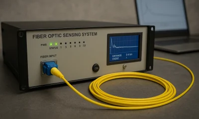
Definition Distributed Acoustic Sensing (DAS) is a technology that converts standard fiber optic cables into dense arrays of vibration sensors. By sending laser pulses through fiber...
Definition A Certified Flight Instructor (CFI) is an aviation professional licensed to teach others how to fly. While traditionally associated with manned aircraft, the term also...
Definition The Civil Air Patrol (CAP) is the official civilian auxiliary of the United States Air Force. It operates under a congressional charter and plays a...
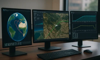
Definition Systems Tool Kit (STK) is a modeling, simulation, and analysis software developed by AGI (Analytical Graphics, Inc.) that enables users to model complex systems—such as...
Definition A Standard Operating Procedure (SOP) is a documented set of step-by-step instructions designed to guide consistent and compliant execution of specific tasks or operations. In...
Definition A Real-Time Network (RTN) is a system of continuously operating reference stations (CORS) that provides high-precision correction data to GNSS receivers in real time. It...
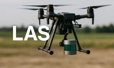
Definition LAS is a standardized binary file format developed for storing LiDAR (Light Detection and Ranging) point cloud data. It preserves critical information such as X,...
Definition Object-Based Image Analysis (OBIA) is a technique in remote sensing and geographic information systems (GIS) that segments an image into meaningful objects rather than analyzing...
Definition Geographic Markup Language (GML) is an XML-based standard for encoding geographic information, including vector data such as points, lines, and polygons. Developed by the Open...